Drone Training
Professional UAS Training by Bush Drone Data
At Bush Drone Data, we believe every drone flight should be backed by precision, safety, and purpose. That’s why we offer structured, high-quality training programs designed for pilots at every level.
Whether you’re a beginner hobbyist or a professional aiming to master advanced drone operations, our training is built to deliver real-world skills, confidence, and operational readiness. Learn from experienced instructors and gain hands-on experience in today’s most in-demand UAS applications.
Train with us and take your drone skills to the next level.
A Collaborative Approach to Drone Education
At Bush Drone Data, we take pride in making drone education accessible, practical, and impactful. Our training programs are designed by professionals with real-world experience in industries such as search and rescue, infrastructure inspection, construction, and environmental monitoring.
By combining technical precision with hands-on instruction, we provide a comprehensive pathway for aspiring pilots to build the skills needed for today’s most in-demand drone applications. Whether you’re just starting out or preparing for advanced operations, our focus is on equipping you with knowledge that translates directly into the field.
Real-world training. Real-world impact.
Drone Training Programs
Bush Drone Data provides a structured suite of UAS training programs engineered to cultivate technical proficiency, operational precision, and regulatory compliance. Our offerings include half-day courses, single-day intensives, and multi-day instructional series, each designed to accommodate varying levels of training depth and professional development objectives.
Every program integrates rigorous, experience-based instruction with FAA-aligned standards, ensuring participants gain not only theoretical knowledge but also the applied competencies necessary for success in complex operational environments. Through this comprehensive approach, we deliver training that advances both the capability and credibility of emerging and established drone professionals.
Instruction Led by Proven Experience
Expertise Behind the Training
Austin Bush, founder of Bush Drone Data, brings over a decade of combined academic, operational, and disaster-response experience to drone education.
As a former instructor at Florida State University (FSU), Austin taught both undergraduate and graduate courses in GIS, UAS applications, drone policy, and emergency management. He also supported courses in leadership, disaster recovery, and conducted specialized training for regional public safety agencies.
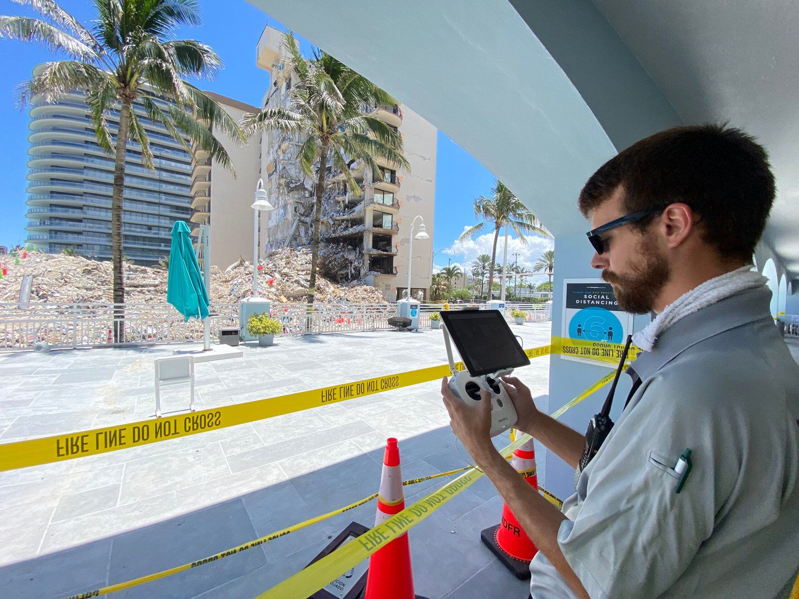
Through his work with the Center for Disaster Risk Policy, Austin deployed with the Disaster Incident Research Team (DIRT) in response to hurricanes, wildfires, missing persons cases, and the Surfside condo collapse. He led student responders and helped implement a robust Incident Command System (ICS) structure for training and deployment.
Austin’s blend of field-tested expertise and academic leadership makes him uniquely qualified to train drone pilots in practical skills, regulatory compliance, and mission-ready operations.
Get Started Today
Whether you’re preparing for your FAA Part 107 exam or aiming to advance into commercial or public-safety UAS roles, Bush Drone Data offers expert training designed to help you succeed.
Ready to begin?
Email us at info@bushdronedata.com or complete the form below to schedule your consultation or enroll in an upcoming course.
Drone Training
Professional UAS Training by Bush Drone Data
At Bush Drone Data, we believe drone operations must be executed with precision, safety, and purpose. To meet that standard, we deliver a structured, high-quality training curriculum designed to educate and prepare the next generation of remote pilots—from recreational enthusiasts to established commercial professionals. Our training philosophy emphasizes both technical mastery and operational discipline, ensuring that every participant develops the skills required to operate safely, efficiently, and with confidence in real-world environments.
Our courses are thoughtfully designed to meet learners at any stage of their journey. For those taking their very first flight, we provide a strong foundation in airspace awareness, flight controls, and regulatory compliance. For professionals advancing into specialized applications, we deliver in-depth instruction in areas such as aerial imaging, photogrammetry, structural inspections, LiDAR mapping, and geospatial data integration. Through a blend of classroom instruction, guided field exercises, and scenario-based training, we ensure participants not only understand the principles of unmanned aviation but can apply them effectively in practice.
By combining industry best practices with hands-on experience, Bush Drone Data equips pilots with the knowledge, confidence, and field-tested techniques they need to thrive. Whether your goal is recreational mastery, professional certification, or advanced operational expertise, our programs provide the pathway to elevate your skills and position you for long-term success in the rapidly evolving UAS industry.
A Collaborative Approach to Drone Education
At Bush Drone Data, we are committed to advancing drone education through programs that balance technical precision with practical application. Our training is designed and delivered by professionals with real-world experience in critical industries such as infrastructure inspection, construction monitoring, emergency response, and geospatial data acquisition.
We provide a comprehensive training pathway that emphasizes operational excellence, regulatory compliance, and industry relevance. By combining structured instruction with hands-on fieldwork, our programs ensure that aspiring and experienced pilots alike develop the knowledge, skills, and confidence to succeed in today’s rapidly evolving UAS landscape.
Drone Training Programs
Bush Drone Data offers a structured suite of drone training programs designed to cultivate technical expertise, operational confidence, and regulatory compliance. Our curriculum is built around progressive stages of learning that align with FAA standards and reflect the demands of today’s most dynamic industries. Each course integrates theoretical instruction with guided, experience-based application to ensure participants gain both conceptual understanding and practical proficiency.
To accommodate the varying needs of our clients, we provide training in multiple formats: half-day courses for introductory instruction and focused skill development, single-day sessions for comprehensive foundational training, and multi-day programs for advanced specialization and mastery. These flexible options are tailored to meet the requirements of a wide spectrum of learners, from individual operators seeking to expand their capabilities to organizations aiming to train entire teams.
By combining rigorous standards with adaptable delivery formats, Bush Drone Data ensures that every participant receives a professional, high-quality learning experience. Whether preparing for your first certification, advancing into complex workflows, or refining specialized operational techniques, our programs are designed to equip you with the knowledge, confidence, and real-world skills necessary for success in the evolving UAS industry.
Instruction Led by Proven Experience
Expertise Behind the Training
Austin Bush, founder of Bush Drone Data, brings over a decade of combined academic, operational, and disaster-response experience to drone instruction.
As an instructor at Florida State University (FSU), he taught undergraduate and graduate-level courses in Geographic Information Systems (GIS), drone policy, UAS applications, and emergency management.
During his time at the Center for Disaster Risk Policy, Austin deployed with the Disaster Incident Research Team (DIRT), conducting UAS operations in response to real-world emergencies such as hurricanes, wildfires, missing persons searches, and the Surfside structural collapse. He led a team of student responders and helped incorporate a robust Incident Command System (ICS) framework for training and deployment.
This combination of field operations and formal education makes Austin uniquely qualified to teach drone pilots who need practical knowledge, regulatory awareness, and operational excellence.

Get Started Today
Whether you’re training to pass your FAA Part 107 exam or looking to expand into commercial and public-safety UAS roles, Bush Drone Data offers training that prepares you for success.
Email us at info@bushdronedata.com or fill out the form below to schedule your consultation or enroll in an upcoming course.
Contact Us
Interested in learning more or have questions about our training services? Fill out the form below and we’ll get back to you shortly. Whether you’re seeking details about scheduling, course content, or custom training options, our team is here to help. We look forward to supporting your goals!


